 |
| Council House Street
The
peace and prosperity following the Battle of Plassey induced people from the
surrounding areas to settle in Calcutta. Kutcha
roads in the new localities inhabited by the natives were full of cesspools.
Wealthier natives constructed roads leading to their houses in the town, or,
suburbs. It is, however, interesting to note that most of the highways from
Calcutta to the suburbs were constructed during the days of the Zamindar.
Steps were also taken to construct bridges over
Dullendaw, Manickchurn, Gopalnagar, Dum Dum, Barasat and Beliaghata Canal in
1766.
The Justices of the Peace for Calcutta
relieved the Zamindar of his municipal duties in 1794 and were authorised to
levy a 5 per cent surcharge on property tax for appointing scavengers,
cleansing, repairing and watching the streets. They also took steps to metal
the Circular Road in 1799. The limited resources placed at the disposal of the
Justices did not permit them to take up large-scale development works like
construction of new roads, bridges etc; in the town.
The East India Company was always unwilling
to part with their revenues for municipal improvements. Funds had to be raised from the public for
development works. Lotteries came to
the aid of the community from 1784 in the creation of public assets. It was the
appointment of Wellesley’s ‘Town Improvement Committee’, later known as the
‘Lottery Committee’ (1804) that took up the initiative to improve the public
thoroughfares of the city. Calcutta owes some of its best roads to the labours
of the Lottery Committee (1825~1836). The roads include: Wood Street, Wellesley
Street, Wellington Street, College Street and Cornwallis Street; Strand Road
from Prinsep Ghat to Hatkhola; Amherst Street; Hare Street; Waterloo Street;
Elliot Road; Short Street; and Colotolla~Mirzapur Street.
A group of streets that commemorated the
various titles of Lord Hastings and his wife, were also the work of the Lottery
Committee and were designed to afford access to the Panchkhotee, or, Five
Mansions. Thus credit goes to the Lottery Committee for reconstructing chaotic
Calcutta into some orderly shape of a modem town.
Circular Garden Reach Road that was called “Strand
New Road to Garden Reach” was constructed in 1828, with contributions from 58
persons. As public opinion in England condemned the method of raising funds by lotteries
for improvement of the town of Calcutta, the Directors of the East India
Company in 1836 ordered their closure.
Lord Auckland (1836-1842) appointed the ‘Fever
Hospital Committee’ to carry on the work of the Lottery Committee. But the new Committee
was more concerned with community health than with roads. The Committee
reported that the streets in the native part of the town were narrow and
haphazard without any free circulation of air. They were always covered with
filth, dust, mud or offal that were rarely cleaned by the scavengers leading to
pestiferous air.
It was as the result of this Report that Bustees were cleared by the Justices of
Peace between 1854 and 1876 for the construction of Halliday Street, Free
School Street, and an extension from Corporation Street to Dharamtollah Street,
Clive Row Extension, Beadon Street, Beadon Square, Grey Street, Allen Square, Outram
Street, Grant Street and the Victoria Terrace.
Construction of new roads and maintenance
of the existing ones were within the exclusive jurisdiction of the Municipal
Corporation of Calcutta from 1876 to 1911. The Corporation mostly cleared or
improved the Bustees to build roads
in the town. The Calcutta Improvement Act of 1911, created a board of trustees
charged with the duty of “opening up congested areas, laying out or altering
streets, providing open spaces for ventilation or recreation”.
The Calcutta Improvement Trust opened up a
north-south and an east-west corridor (Central Avenue and Rashbehari Avenue)
and many other roads in the city.
The completion of the underground drainage
and water supply schemes resulted in the construction of the Suburban High Level
Sewer Road and the conversion of many open drains or ditches into narrow lanes.
The implementation of the Canal Area (between Circular Canal and Upper Circular
Road) Drainage Scheme in 1907 resulted in the construction of 11,596 feet of roads,
60 feet in width and 13,970 feet of new roads, 40 feet in width, in addition to
the widening of the existing ones.
It took another 40-odd years before further
development works of new roads in the city were planned.
concluded
|
Thursday 30 April 2015
‘Song of the Road’… A Brief History of the City’s Roads (1700s ~ 1900s): Part Two
Monday 27 April 2015
‘Song of the Road’… A Brief History of the City’s Roads (1700s ~ 1900s): Part One
 |
| Pilgrim Road (Chitpur Road) in the 1760s |
The
construction of roads and their maintenance is an important indicator of urban
planning. It also indirectly affects the sanitation in a city. There were
practically no roads in the villages that grew into Calcutta, as they were
sparsely inhabited. The only pathway was the Pilgrim Road — what is known today
as the Chitpur Road — that led to the Kali Temple. The British East India
Company as well as the British Government, who took over the administration of
the city of Calcutta in 1857, had constructed roads for their ease of movement.
Historically, construction of roads in early Calcutta can be traced over three
specific periods. They are:
- Days of the Zamindar (1700~1793);
- Days of Justices of the Peace (1794~1876); and
- Municipal Corporation (since 1876)
Roads in Calcutta During Eighteenth Century
|
Year
|
Streets
|
Lanes
|
By-Lanes
|
|
1706
|
2
|
0
|
0
|
|
1726
|
4
|
8
|
0
|
|
1742
|
16
|
46
|
74
|
|
1756
|
27
|
52
|
74
|
|
1794
|
163
|
520
|
517
|
Source: AK Ray: “Short History of Calcutta”; Census Report of India,
1901; Volume VII, Calcutta; ‘Town and Suburbs’; Part I, Calcutta
CR Wilson’s Old
Fort William in Bengal reports that the authorities constructed new roads
from Fort William to Gobindapur in 1721 for making the place healthier “by the
wind’s free passage into the town”. The construction of roads in Calcutta
during the days of the Zamindar was primarily carried out by taking
contributions from the merchants and local residents. The English Company
encouraged voluntary contributions in labour and money for development works of
the town. The Company was not authorised by the British Parliament to levy tax
on inhabitants of Calcutta for effecting town improvements till 1794. The
Circular Road (now called Acharya Prafulla Chandra and Acharya Jagadish Bose
Roads) was the result of the voluntary efforts of the citizens of Calcutta.
By 1742, Calcutta had 16 streets and 46 lanes. Few
of the roads marked in Orme’s Plan of Calcutta 1742, lying within the Maratha
Ditch, had received their present-day names — the ‘Avenue leading to the eastward’
(Bowbazar Street or Bipin Behari Ganguly Street); ‘Road to Dum Dum’, ‘Causeway’
(Manicktollah Road, subsequently renamed as Sookea Street, Baranasi Ghose
Street etc); and ‘Road to Kalighat’.
 |
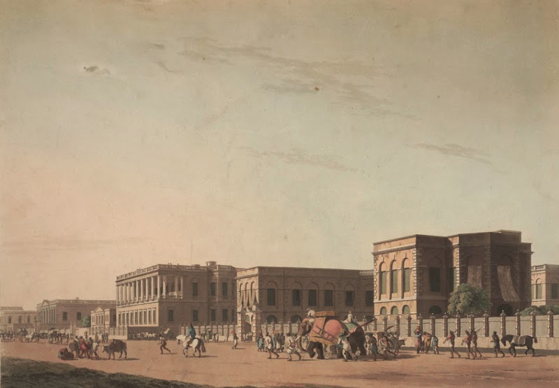
| Dalhousie Area (circa 1780) |
Captain William Holcombe’s report of 1742,
contained references to a ‘Road towards Pennings’ (Chitpur Road up to
Baghbazar), and, an ‘Avenue towards the Water Side’ (Nimtala Ghat Street). A
number of roads were also repaired by the Zamindars in 1749. The roads
included:
1. “The Road from the Dock Head to the
Stable and down to the side of the Park” (Hare Street and road along Dalhousie
Square to Vansittart Row);
2. “The Street from the side and back of Mr
Rooper’s House and down to Messrs Noke’s and Lascelles’s House” (Mangoe Lane);
3. “The Road from Captain Lloyd’s house to
the New Bazar, Chandpal Bazar” (Esplanade Row West);
4. “The Road from New Bridge to Barthola
Bazar” (Chitpur Road);
5. “The Road from the Fort Gate to Mansingh’s
Chowki” (Lalbazar~Bowbazar Street);
6. “The Road from Chowrighee’s Chowki and
Gusthulla Bazaar” (Bentinck Street~Chowringhee Road up to Park Street);
7. “The Street from Margass’s House down to
the Powder House” (Council House Street);
8. “The Street from Purana Gunge to Gobindapur
Chowki” (a road that has now merged in the Maidan);
9. “The Street to the side of the Goal down
to Mr Frankland’s Garden” (a road from Tiretta Bazaar to Middleton Row; and
10. “The
Street from Omichund’s House to Mir Bahar Chowki” (China Bazaar~ Mir Bahar Ghat
Street).
With the recapture of
Calcutta from Siraj-ud-Dowlah in 1757, new roads were laid out in the Maidan in
the early part of the nineteenth century. Englishmen, who were confined to
their settlement at Tank Square, moved out to Chowringhee and the suburbs after
1760. The acquisition of the Zamindari rights of the 24-Parganas in 1757 helped
the Company to expand the limits of Calcutta from time to time.
to be continued
Saturday 25 April 2015
On The Drain Front… A Brief History of the City’s Sewerage & Drainage System (1700s ~ 1950s)

It appears to have taken 16 years to complete the
main sewers of Clark’s Scheme. By 1875 nearly
38 miles of brick and 37 miles of stoneware pipe sewers were constructed. The
pumping plant at Palmer’s Bridge comprised two 30 and one 45 PHP vertical
centrifugal steam pumps and two huge silt-pits provided with penstocks. These
penstocks also shut off the flow of the sewers from the channel to the
Beliaghata Canal. During the rainy season they were opened so that the sewers
could discharge fully into the canal providing a great relief from storm-water
overflows between Upper Circular Road sewer and the Circular Canal. The drainage
works of the Southern Division were finally completed in 1878 and those of the
Northern Division between 1885-86.
Clark’s original scheme was not complete when the
Corporation was compelled to undertake additional works to prevent the
discharge of storm-water into the canal. Calcutta’s Canals (Circular, New Cut,
Bhangur Khal, Kestopur and Tolly’s Nullah) though excavated principally for
navigation, helped in draining the City to a considerable extent by carrying
storm-water until the end of the nineteenth century. In 1880, however, the
Government Irrigation authorities objected to the storm-water being discharged
into the canal, although there could be no doubt that the canal had intercepted
the natural surface drainage channels of the city. The Government in 1881-82 stopped the
discharge of storm water into the Circular Canal. The city drainage was thus
disoriented and the escapes into the Circular Canal had to be checked by a long
intercepting sewer that diverted the drainage to the existing Town Head Cut.
After a long controversy with the Government the
Corporation reluctantly agreed in 1881 to: (i) construct an intercepting sewer
to increase the dimension on the outfall channel (the open cut) to a capacity
of about 90,000 cubic feet per minute; (ii) to construct tide-gates of four
openings 10 feet wide at Makalpotta; and, (iii) to divert the storm-water of
the northern area of the city to the Beliaghata Canal below Dhapa.
This intercepting sewer ran parallel with and close
to the canal from Habsi Bagan Road to Palmer’s bridge, where it joined the
outfall channel. But unfortunately it was constructed, like most of the city
sewers, with the smaller sections joining the larger invert to invert and the
levels at which it was constructed did not allow it to take the required
discharges from the storm overflows without causing the water to stagnate in
the low-lying areas of the city. There
were 37 miles of main or brick sewers and 147 miles of pipe sewers in Calcutta
by 1890.
The Added and Fringe Areas, covering 8188 acres,
were incorporated in the town of Calcutta in 1889. The development of these
areas was entrusted to a committee, called the Suburban Improvement Committee. For
the purpose of drainage the new areas fell naturally into 3 blocks:
I.
The
portion west and south of Tolly’s Nullah, including the new docks. This drained
towards the south and southwest;
II.
The
area east of Tolly’s Nullah, including Ballygunge and Entally. This drained
towards the Bidyadhari; and
III.
The
area lying between the Circular canal, Circular Road and the Eastern Bengal
State Railway lines, devoid of all drainage except in so far as the drains of
Calcutta provided outlets
Under the Suburban Sewerage Scheme executed between
1891 and 1906, 12.5 square miles (32 sqkms) in the newer southern areas of the
city were covered. A new pumping station was constructed at Ballygunge and the
capacity of the Palmer’s Bridge station augmented. The drainage system could,
therefore, dispose off storm-water from one-fourth of an inch rainfall per hour
plus 40 gallons of sewage per inhabitant per day. This ‘combined drainage’ flow was brought
through the underground sewerage network to Palmer’s Bridge and Ballygunge
pumping stations. It was then pumped into high-level sewers meeting at a place called
“Topsia A”. From here, the discharge flowed by gravity directly into Raja Khal,
a creek of the tidal river Bidyadhari.
Burdened with the outfall of the entire city’s
drainage system, the Bidyadhari began to show signs of rapid deterioration. In
1928, the Government declared it to be a dead river. The city was thence almost
trapped in a drainage deadlock. At this juncture, Dr Birendranth Dey (1891-1963) came up with a new scheme for both the outfall
and the internal drainage system. The Outfall Scheme comprised of:
I.
Lined
dry-weather flow channel from Topsia A to the river Kultigong at Ghusighata,
discharging into the river through a sluice at the outfall
II.
Storm-water
flow channel (the Suburban Head Cut) from Ballygunge drainage pumping station
to the Kultigong at Ghusighata, discharging through the above mentioned sluice
III.
Storm-water
flow channel (the Town Head Cut) direct from Palmer’s Bridge Pumping Station,
joining the dry-weather flow channel near Topsia A at Bantala, where provision
was made for two sedimentation tanks for primary treatment of the dry-weather
flow
IV.
Storm-water
flow channel from the Dhapa lock pumping station, joining the channel with the
above mentioned one at Makalpota
This Scheme was commissioned
only in 1943. It has since undergone major modifications and expansion to meet
the rapid growth of the city’s area and population.
concluded
Friday 24 April 2015
On The Drain Front… A Brief History of the City’s Sewerage & Drainage System (1700s ~ 1950s)

In
the initial years of the city’s growth, the merchants of the East India Company
were not much interested in providing improved civic amenities to the citizens.
Some of money the Company collected by imposing taxes, duties and licenses in
Calcutta between 1690-1723 by virtue of the zamindari rights they had acquired
over the villages of Sutanuti, Kolkata and Govindpur in 1698 was put to develop
the settlements’ civic structure.
The civic services rendered by the Zamindar mainly
consisted of: water supply, drainage, cleansing of streets and street lighting.
The development activities undertaken by the Zamindar included: cutting down
the jungles in the town, bridging the watercourses, surveying the lands and
other such affairs. The provision of ‘civic amenities’ in the city was brought
under the Municipal Administration in 1727.
Calcutta had its natural drainage through the Khal (creek) that originated from the Salt Lakes in the east and joined the Hooghly
River just below the Prinsep Ghat, after meandering through Beliaghata, Sealdah, Creek Row, Dharamtollah and Government
Place North. The great cyclone of 1737 rendered this creek useless as a
watercourse for navigation.
Small surface drains had existed in the city since
1695 when a trench was dug round the Sutanuti factory. A deeper trench was
constructed in 1710 to separate the British settlement from the indigenous
settlement and keep the former dry and wholesome. The ditch ran from Lalbazaar
probably to Baboo Ghat. It was protected with drawbridges and a guardhouse — as
it basically served the defense rather than drainage purposes.
In 1742 the Maratha Ditch was constructed initially
from Baghbazar to Park Street and then extended to Alipore. This was mainly for the defense against the
Maratha raids but it served also as the grand drainage outlet for the whole
city until 1801 when it was filled up.
But the state of affairs changed for the better on
June 16, 1803. In a meeting of the “Town Improvement Committee” chaired by Lord
Wellesley, the then Governor General of Bengal, a historic initiative was
undertaken.
It was at Wellesley’s behest that the “Town Reforms
Committee” was formed for improvement of the town. Since the construction of
the public drains and watercourses of the Town was extremely defective, he
assigned great importance to the improvements of its drainage.
This led to the appointment of a Committee in 1804 to
look into the matter. This Improvement Committee, later called the Lottery
Committee, undertook extensive development work for Calcutta by constructing
roads and filling up filthy tanks in the town and excavating new ones. Beliaghata
Canal was the Lottery Committee’s permanent contribution to the city’s drainage
system.
It is reported that during the early nineteenth
century, the drains in the northern part of the town were unpaved and filthy. Coolies
were employed regularly to clean these drains manually that would overflow on
to the streets after a light rainfall as these drains had no outlet.
As a result, various proposals came up between
1835-1855 for the construction of a new drainage system in the ‘Town’:
•
The
Committee opted for an underground drainage system
•
Captain
Prinsep of the Bengal Engineers preferred a surface drainage system to carry
off the water with sinks and ash-pits for every house, to be cleansed by manually.
He strongly opposed to any scheme of underground drainage in Calcutta
•
Mr
Blechynden, proposed to drain the northern portion of the town, in which no
large drains had yet been made, either towards the river or to the east by a
large underground tunnel running from the Hooghly down Nimtala and Manicktollah
streets to the Circular Canal. The tunnel was to be flushed by the admission of
the Hooghly water
• Captain
Thomson provided for an elaborate system of large underground drains or sewers
that he proposed to flush partly by river water and partly by means of a
reservoir to be formed at the western end of the Entally Canal
•
Captain
E Forbes proposed to construct a large masonry aqueduct from the river Hooghly
at old Chitpur Bridge to the Old Park Street cemetery and link it with the Salt
Lakes by a wide-open canal nearly parallel with Entally canal. The canal was to
be connected by sluice gates with the river and lake, so that water might be
admitted or excluded from both these sources. On either side of the canal
masonry sewer or covered drain was to be constructed and linked with a system
of subsidiary drains discharging into these two main sewers all the filth and
surface drainage of the city
•
William
Clark proposed a “water-carriage system” for the town. The original report was
submitted to the Municipal Commissioners in 1855, and adopted in 1857 with some
modifications and was sanctioned in 1859. Clark’s scheme was a ‘combined
sewage-cum drainage system’. It carried off both rainfall and sewage from the Hooghly
to the Salt Lakes from where the sewage was to be pumped out. The total town
area that was covered under Clark’s Scheme amounted to 4730 acres
Clark’s Scheme comprised of
five main sewers with their branches, accessories and outfall works. Three of
the main sewers stretched from the Hooghly to the Circular Road along the Nimtala
Ghat Street, Colootola Stree and Dharamtollah Street. There were two main
intercepting sewers:
•
One
from the north, starting from Hooghly at Sova Bazaar Street running eastward to
Circular Road and continuing along Upper Circular Road to a level at Dharamtollah
junction. It intercepted the three main sewers already mentioned. Between this
Circular Road sewer and the Circular Road canal, he provided four storm-water
overflows of much larger capacity than the sewers
• The other intercepting
sewer started from Tolly’s Nullah near Zeerut Bridge, and following Lower Circular
Road to Dharamtollah junction. It discharged together with the sewer from the
north and the Dharamtollah sewer through a main outfall to Palmer’s Bridge Pumping
station in Entally, and thence into the Beliaghata Canal
to be continued
Thursday 23 April 2015
“Deshbandhu” Chittaranjan Das… Saluting Kolkata’s Premier ‘First Citizen’
 |
| Deshbandhu Chittaranjan Das |
On April 16, 1924 ‘Deshbandhu’ Chittaranjan Das was
elected as the first Mayor of Kolkata. Subsequently with the
promulgation of the new Calcutta Municipal Act of 1923, he was reelected on April
1, 1925. Thus began a glorious chapter in the history of Kolkata’s civic
administration. A successful lawyer, it was Chittaranjan’s vision that
propelled Kolkata’s development — for the first time in an indigenous model.
Chittaranjan Das was born on
November 5, 1870. His father, Bhuban Moahan Das who was a Solicitor at the
Calcutta High Court, who hailed from a well-known family of Bikrampur in the Dhaka
district of the then Bengal Province.
After
completing his education from the London Missionary Society’s School, Calcutta,
Das joined the hallowed Presidency College and took his Bachelor’s Degree from
Calcutta University in 1890. It was during his student days that Chittaranjan became
a firm believer in the political ideals of Bankim Chandra Chatterjee. At
Presidency, he was a leading figure of the Students Association where he was
baptised by the fire under Surendranath Banerjee in the first lessons in public
service and elocution.
In 1891, Chittaranjan Das went to England and
joined the Inner Temple to
study Law and was called to the Bar in 1892. During his stay in England he made
several political speeches, notably in support of the Parliamentary candidature
of Dadabhai Naoroji, the first Indian to be elected to the House of
Commons.
Das returned to India in 1893 and commenced his
practice as a Barrister in the High Court of Calcutta. His career reached a new height in the year 1909 when he successfully
defended Aurobindo Ghosh in the famous ‘Alipore Bomb Blast Case’. It was this
momentous event that made him ‘Deshbandu’, or, ‘Friend of the Nation’ in the
eye of millions of his fellow countrymen.
In 1917 Das came to the forefront
of nationalist politics when he was invited to preside over the Bengal
Provincial Conference held at Bhowanipore. This triggered off Chittaranjan as a
major figure in the Non-Cooperation Movement from 1919 to 1922.
As man Das set high morale standards, thus
it was not surprising that for someone who maintained a permanent laundry in
Paris to ship his clothes to Calcutta — it was he who started the boycott of
western dresses — setting an example for others to follow by burning his own
western clothes and instead, adopting the handmade desi Khadi garments.
A firm believer of non-violence and constitutional
methods for the realisation of national independence, Das advocated
Hindu-Muslim unity, cooperation and communal harmony and championed the cause
of national education. This led to the formation of the Swaraj Party in 1924
after he resigned his presidency of the Indian National Congress at the Gaya
session along with Motilal Nehru and Hussain Suhrawardy. It was around this time that Das also
launched a newspaper named Forward to
spread his message to the public and fight the British Raj that was later
rechristened as Liberty.
As the first Mayor of Kolkata Chittaranjan
blueprinted his vision of liberating India from British Rule by means of proper
self-governance. For him, Corporation
was the ‘Working model of Swaraj’. In order to realise his dream, Chittaranjan
appointed Subhas Chandra Bose as the first Chief Executive of the Corporation
who ably furthered the former’s goal of serving the country and its people.
In 1925, Das’s health began to
fail due to overwork and in May he withdrew to “Step Aside”, his retreat in
Darjeeling. On 16 June 1925 Chittaranjan breathed his last with a severe fever.
Mahatma Gandhi, who led thousands in Calcutta, during Das’s funeral procession,
famously opined, “Deshbandhu was one of the greatest of men... He dreamed...
and talked of freedom of India and of nothing else... His heart knew no
difference between Hindus and Mussalmans and I should like to tell Englishmen,
too, that he bore no ill-will to them.”
A few years before his death Das
gifted his house and the adjoining lands to the nation to be used for the
betterment of the lives of women. Today it is a major hospital called Chittaranjan Seva Sadan and has gone
from being a women’s hospital to one where all specialties are present. The
Chittaranjan Cancer Hospital that was established in these premises in 1950 is
now the Chittaranjan National Cancer Institute. The Corporation and the citizens paid tribute to Chittaranjan Das by erecting
a commemorative tower at the Keoratala Mahasmashan where Chittaranjan was
cremated.
It is indeed a privilege for us at Corporation to pay our tribute to
Deshbandhu every year at this monument.
 |
| Step Aside… Das's residence at Darjeeling |
Friday 17 April 2015
Remembering Kshitish Prasad Chattopadhyay… The ‘Renaissance Man’ of our City’s Primary Education
 |
| Kshitish Prasad Chattopadhyay |
Amongst the visionaries
who blueprinted Kolkata Municipal Corporation’s destiny Kshitish Prasad Chattopadhyay’s
name stands tall, for his immense contribution in shaping the Corporation’s roadmap
in the domain of education. In this piece, we pay our humble tribute to Kshitish
Prasad ─ whose vision helped materialise Subhas Chandra Bose’s “mission of spreading
primary education to the grassroots in Kolkata”.
Kshitish Prasad
Chattopadhyay was born on December 15, 1897 in Kolkata. Chattopadhyay’s father,
Yamani Mohan was the descendent of Raja Ram Mohun Roy, the ‘Bengal Renaissance
Man’ and Ishwar Chandra Vidyasagar. While his mother, Motimala was the
granddaughter of Dwarkanath Tagore.
In 1913 Subhas
Chandra Bose passed the Matriculation standing second, while his batch mate Kshitish
stood seventh from the Metropolitan Institution. This paved the way for Chattopadhyay’s
brilliant academic career ─ two years later, he stood first in the ISC
Examinations. In 1917 he passed BSc in Physics with first class and followed it
up with his MSc in Anthropology from Cambridge University receiving ‘Anthony
Wilkins Fellowship’ in 1922.
On his return to India
Chattopadhyay joined Calcutta University as a Professor in 1923. In 1924 Deshbandhu
Chittaranjan Das assumed office of the Mayor in Calcutta Corporation and
appointed Subhas Chandra as its first Chief Executive. It was on Bose’s behest
that Kshitish Prasad was chosen as the Corporation’s Education Officer.
What followed was
unprecedented in the history of the Corporation, not to mention the City. Under
Chattopadhyay’s stewardship the number of Corporation Schools swelled from a
meagre three to a total of 232. A momentous feat that changed the face of
primary education of Kolkata forever.
Till 1935 he served Calcutta
Corporation as the Education Officer and then, on the invitation of Shyama
Prasad Mukherjee, once again joined the Calcutta University. A man of
scholastic proportions, Kshitish Prasad, a student of WHR Rivers in his later
life also Headed the Department of Anthropology, University of Calcutta.
A recipient of the prestigious Sarvabhauma Award from the Calcutta Pandit Samaj, Kshitish Prasad was a member of Permanent Council of International Congress of Anthropology. He passed away on March 31, 1963.
Subscribe to:
Posts (Atom)