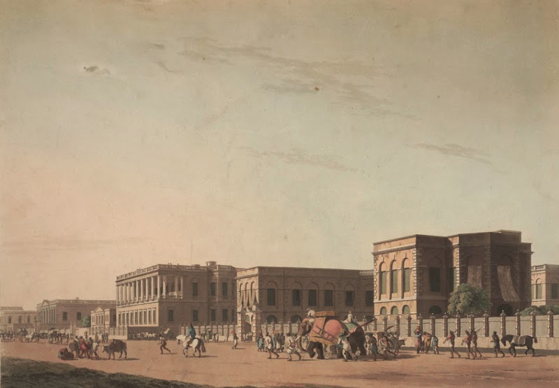
 |
| Council House Street
The
peace and prosperity following the Battle of Plassey induced people from the
surrounding areas to settle in Calcutta. Kutcha
roads in the new localities inhabited by the natives were full of cesspools.
Wealthier natives constructed roads leading to their houses in the town, or,
suburbs. It is, however, interesting to note that most of the highways from
Calcutta to the suburbs were constructed during the days of the Zamindar.
Steps were also taken to construct bridges over
Dullendaw, Manickchurn, Gopalnagar, Dum Dum, Barasat and Beliaghata Canal in
1766.
The Justices of the Peace for Calcutta
relieved the Zamindar of his municipal duties in 1794 and were authorised to
levy a 5 per cent surcharge on property tax for appointing scavengers,
cleansing, repairing and watching the streets. They also took steps to metal
the Circular Road in 1799. The limited resources placed at the disposal of the
Justices did not permit them to take up large-scale development works like
construction of new roads, bridges etc; in the town.
The East India Company was always unwilling
to part with their revenues for municipal improvements. Funds had to be raised from the public for
development works. Lotteries came to
the aid of the community from 1784 in the creation of public assets. It was the
appointment of Wellesley’s ‘Town Improvement Committee’, later known as the
‘Lottery Committee’ (1804) that took up the initiative to improve the public
thoroughfares of the city. Calcutta owes some of its best roads to the labours
of the Lottery Committee (1825~1836). The roads include: Wood Street, Wellesley
Street, Wellington Street, College Street and Cornwallis Street; Strand Road
from Prinsep Ghat to Hatkhola; Amherst Street; Hare Street; Waterloo Street;
Elliot Road; Short Street; and Colotolla~Mirzapur Street.
A group of streets that commemorated the
various titles of Lord Hastings and his wife, were also the work of the Lottery
Committee and were designed to afford access to the Panchkhotee, or, Five
Mansions. Thus credit goes to the Lottery Committee for reconstructing chaotic
Calcutta into some orderly shape of a modem town.
Circular Garden Reach Road that was called “Strand
New Road to Garden Reach” was constructed in 1828, with contributions from 58
persons. As public opinion in England condemned the method of raising funds by lotteries
for improvement of the town of Calcutta, the Directors of the East India
Company in 1836 ordered their closure.
Lord Auckland (1836-1842) appointed the ‘Fever
Hospital Committee’ to carry on the work of the Lottery Committee. But the new Committee
was more concerned with community health than with roads. The Committee
reported that the streets in the native part of the town were narrow and
haphazard without any free circulation of air. They were always covered with
filth, dust, mud or offal that were rarely cleaned by the scavengers leading to
pestiferous air.
It was as the result of this Report that Bustees were cleared by the Justices of
Peace between 1854 and 1876 for the construction of Halliday Street, Free
School Street, and an extension from Corporation Street to Dharamtollah Street,
Clive Row Extension, Beadon Street, Beadon Square, Grey Street, Allen Square, Outram
Street, Grant Street and the Victoria Terrace.
Construction of new roads and maintenance
of the existing ones were within the exclusive jurisdiction of the Municipal
Corporation of Calcutta from 1876 to 1911. The Corporation mostly cleared or
improved the Bustees to build roads
in the town. The Calcutta Improvement Act of 1911, created a board of trustees
charged with the duty of “opening up congested areas, laying out or altering
streets, providing open spaces for ventilation or recreation”.
The Calcutta Improvement Trust opened up a
north-south and an east-west corridor (Central Avenue and Rashbehari Avenue)
and many other roads in the city.
The completion of the underground drainage
and water supply schemes resulted in the construction of the Suburban High Level
Sewer Road and the conversion of many open drains or ditches into narrow lanes.
The implementation of the Canal Area (between Circular Canal and Upper Circular
Road) Drainage Scheme in 1907 resulted in the construction of 11,596 feet of roads,
60 feet in width and 13,970 feet of new roads, 40 feet in width, in addition to
the widening of the existing ones.
It took another 40-odd years before further
development works of new roads in the city were planned.
concluded
|
Showing posts with label Beliaghata Canal. Show all posts
Showing posts with label Beliaghata Canal. Show all posts
Thursday, 30 April 2015
‘Song of the Road’… A Brief History of the City’s Roads (1700s ~ 1900s): Part Two

Saturday, 25 April 2015
On The Drain Front… A Brief History of the City’s Sewerage & Drainage System (1700s ~ 1950s)

It appears to have taken 16 years to complete the
main sewers of Clark’s Scheme. By 1875 nearly
38 miles of brick and 37 miles of stoneware pipe sewers were constructed. The
pumping plant at Palmer’s Bridge comprised two 30 and one 45 PHP vertical
centrifugal steam pumps and two huge silt-pits provided with penstocks. These
penstocks also shut off the flow of the sewers from the channel to the
Beliaghata Canal. During the rainy season they were opened so that the sewers
could discharge fully into the canal providing a great relief from storm-water
overflows between Upper Circular Road sewer and the Circular Canal. The drainage
works of the Southern Division were finally completed in 1878 and those of the
Northern Division between 1885-86.
Clark’s original scheme was not complete when the
Corporation was compelled to undertake additional works to prevent the
discharge of storm-water into the canal. Calcutta’s Canals (Circular, New Cut,
Bhangur Khal, Kestopur and Tolly’s Nullah) though excavated principally for
navigation, helped in draining the City to a considerable extent by carrying
storm-water until the end of the nineteenth century. In 1880, however, the
Government Irrigation authorities objected to the storm-water being discharged
into the canal, although there could be no doubt that the canal had intercepted
the natural surface drainage channels of the city. The Government in 1881-82 stopped the
discharge of storm water into the Circular Canal. The city drainage was thus
disoriented and the escapes into the Circular Canal had to be checked by a long
intercepting sewer that diverted the drainage to the existing Town Head Cut.
After a long controversy with the Government the
Corporation reluctantly agreed in 1881 to: (i) construct an intercepting sewer
to increase the dimension on the outfall channel (the open cut) to a capacity
of about 90,000 cubic feet per minute; (ii) to construct tide-gates of four
openings 10 feet wide at Makalpotta; and, (iii) to divert the storm-water of
the northern area of the city to the Beliaghata Canal below Dhapa.
This intercepting sewer ran parallel with and close
to the canal from Habsi Bagan Road to Palmer’s bridge, where it joined the
outfall channel. But unfortunately it was constructed, like most of the city
sewers, with the smaller sections joining the larger invert to invert and the
levels at which it was constructed did not allow it to take the required
discharges from the storm overflows without causing the water to stagnate in
the low-lying areas of the city. There
were 37 miles of main or brick sewers and 147 miles of pipe sewers in Calcutta
by 1890.
The Added and Fringe Areas, covering 8188 acres,
were incorporated in the town of Calcutta in 1889. The development of these
areas was entrusted to a committee, called the Suburban Improvement Committee. For
the purpose of drainage the new areas fell naturally into 3 blocks:
I.
The
portion west and south of Tolly’s Nullah, including the new docks. This drained
towards the south and southwest;
II.
The
area east of Tolly’s Nullah, including Ballygunge and Entally. This drained
towards the Bidyadhari; and
III.
The
area lying between the Circular canal, Circular Road and the Eastern Bengal
State Railway lines, devoid of all drainage except in so far as the drains of
Calcutta provided outlets
Under the Suburban Sewerage Scheme executed between
1891 and 1906, 12.5 square miles (32 sqkms) in the newer southern areas of the
city were covered. A new pumping station was constructed at Ballygunge and the
capacity of the Palmer’s Bridge station augmented. The drainage system could,
therefore, dispose off storm-water from one-fourth of an inch rainfall per hour
plus 40 gallons of sewage per inhabitant per day. This ‘combined drainage’ flow was brought
through the underground sewerage network to Palmer’s Bridge and Ballygunge
pumping stations. It was then pumped into high-level sewers meeting at a place called
“Topsia A”. From here, the discharge flowed by gravity directly into Raja Khal,
a creek of the tidal river Bidyadhari.
Burdened with the outfall of the entire city’s
drainage system, the Bidyadhari began to show signs of rapid deterioration. In
1928, the Government declared it to be a dead river. The city was thence almost
trapped in a drainage deadlock. At this juncture, Dr Birendranth Dey (1891-1963) came up with a new scheme for both the outfall
and the internal drainage system. The Outfall Scheme comprised of:
I.
Lined
dry-weather flow channel from Topsia A to the river Kultigong at Ghusighata,
discharging into the river through a sluice at the outfall
II.
Storm-water
flow channel (the Suburban Head Cut) from Ballygunge drainage pumping station
to the Kultigong at Ghusighata, discharging through the above mentioned sluice
III.
Storm-water
flow channel (the Town Head Cut) direct from Palmer’s Bridge Pumping Station,
joining the dry-weather flow channel near Topsia A at Bantala, where provision
was made for two sedimentation tanks for primary treatment of the dry-weather
flow
IV.
Storm-water
flow channel from the Dhapa lock pumping station, joining the channel with the
above mentioned one at Makalpota
This Scheme was commissioned
only in 1943. It has since undergone major modifications and expansion to meet
the rapid growth of the city’s area and population.
concluded
Subscribe to:
Posts (Atom)